The study analyses the variations of rainfall across 37 climate research unit (CRU) stations of Nigeria from 1901 to 2021, using descriptive research design. The study employed monthly rainfall using the 5o x 5o latitude and longitude grid points sampling techniques. Data collected were statistically analysed with descriptive and inferential statistics. Findings revealed that mean general rainfall in Nigeria is 1488.6mm, with wettest year of 1792.7mm in 1957. The spatial distribution of rainfall showed that Cross River station recorded the highest mean rainfall of 2679.5mm, followed by Akwa Ibom (2624.1mm), and 631.3mm being the lowest recorded mean rainfall observed in Borno station. Linear regression results established that latitude statistically predicted rainfall in Nigeria at F (3, 33) = 3.41, P = 0.05; while latitude, longitude, and altitude accounted for 16.7% of the factors affecting rainfall variability in Nigeria. The regression equation was: predicted rainfall = 2482.6 + -123.5 + 6.305 + -.0510x (latitude, longitude and altitude). Results of ANOVA test showed that significant difference exists amongst the means rainfall in all Nigerian States at F (36, 4440) = 1.419334, P = 0.000). Post hoc test using Dunnett showed that the mean differences are in Cross River, Akwa Ibom, Bayelsa, Rivers, Delta, Abia, Owerri, Ebonyi, Edo, Enugu, Anambra, Lagos, Benue, Ondo, Oyo, Ekiti, Osun, Ogun, Plateau, Kogi, Abuja, Kwara, Nasarawa, Niger, Kaduna, Taraba, Zamfara, Bauchi, Adamawa, Gombe, Kebbi, Kano, and Yobe, Jigawa. The distribution of rainfall varied spatially across the different CRU stations in Nigeria.
Keywords
Climatic variations
Ecological stations
Meteorological parameters
Rainfall analysis
Rainfall seasonality.
Important Note
Key findings:
The study found Nigeria's mean annual rainfall is 1488.6mm, with the highest in Cross River (2679.5mm) and the lowest in Borno (631.3mm). Latitude, longitude, and altitude account for 16.7% of rainfall variability. Significant differences in rainfall exist among Nigerian states, with the wettest year in 1957.
What is known and what is new?
Rainfall distribution in Nigeria varies across regions, influenced by geographic factors such as latitude, longitude, and altitude. This study provides updated rainfall data from 1901 to 2021, identifies the highest and lowest rainfall regions, and quantifies the impact of geographic factors on rainfall variability, revealing significant differences among states.
What is the implication, and what should change now?
The study's findings highlight the significant spatial variability of rainfall in Nigeria, emphasizing the need for region-specific water resource management and agricultural planning. Policymakers and planners should use this updated rainfall data to tailor strategies for water conservation, flood management, and agricultural practices to better accommodate the distinct rainfall patterns of each region.
Introduction
In various susceptible regions of the world, rainfall is one of the most strongly significant climatic factors causing floods and droughts [1-3]. Rainfall as a climatic factor has impact on almost all human activities. To estimate or quantify the amount of water that is sufficient to meet different demands such as those for agriculture, industrial, domestic water supply, and power generation, for instance, the sum of rainfall that an area receives is a key determinant element [4,5]. Planning for disasters and the economy of any State both heavily rely on rainfall variability and the pattern of extremely high or low precipitation.
Extreme rainfall is one of the most dangerous meteorological occurrences that can harm people's lives, properties, and their economy [6]. According to research, there is the possibility that in many parts of the world, within the 21st century, the total sum of rainfall and the occurrence of severe rainfall would increase (Intergovernmental Panel on Climate Change [IPCC], 2012)[7]. According to Igwenagu (2014) [8], since the 1970s, there has been an atmospheric imbalance, and the planet has been subjected to a scheme of climate change precedents. The researcher added that there are theories on how precipitation patterns vary globally and that weather patterns have changed through time, particularly concerning rainfall in sub-Saharan Africa, including Nigeria. According to Onyekuru & Marchant (2014) [9], While the southern sub-region of the country has witnessed an inconsistent upward trend in rainfall, the northern sub-region has seen a decline in rainfall and a rise in the measures of aridity and heat [9,10].
Heavy tropical rains in Nigeria's wet season, frequently followed by flash floods, can occasionally result in fatalities and associated activities, especially in rural areas and densely populated cities because of inadequate or non-existence of effective drainage [11,12]. The National Emergency Management Agency estimated in 2012 that 30 of Nigeria's 36 states were affected by the 2012 national flood, which resulted in over 1 million people being displaced and over 400 fatalities [13]. The floods that hit Nigeria in 2022 between June and November were among the deadliest ever recorded. More than 500,000 hectares of crops were damaged, there were hundreds of deaths, and 1.5 million people were displaced.
A study by Ndakara and Eyefia (2021) [5] examined the geographical and seasonal differences in rainfall in Nigeria, and observed significant disparities amongst Nigerian states' seasonal changes in rainfall while trends in the amount of rainfall increased. Akinsanola and Ogunjobi (2014) [14] used observations of rainfall (mm) from 25 synoptic stations over 30 years to examine rainfall variations in Nigeria. The great majority of the country has experienced substantial rises in rainfall and air temperature, according to the results. Analysis of the time series' long-term and decadal patterns also points to a pattern of alternating decline and increase in trends of Nigeria's mean annual precipitation. Igwenagu (2014) [8] used data on the average rainfall over eleven years to study the rainfall patterns in Nigeria. The outcome indicated that the pattern of rainfall increased steadily for five years throughout the study period. For the remainder of the year, the trend was inconsistent with some form of fluctuations. The seventh year of the study period, or 2008, corresponded to the peak time, which was visible on the sequence plot. The Mann-Kendall test revealed that whereas rainfall trends were on the rise in Enugu, Calabar, and Ikeja, they were on the decline in Ilorin, Kaduna, and Maiduguri.
Using monthly rainfall data from 1901 to 2012, Adenodi (2018) [15] analyses rainfall variability in Nigeria. The results showed that rainfall was at its lowest and highest levels in January and August, respectively. The Z and Q statistics show an increasing trend and a positive slope, respectively. However, due to extremely little rainfall in November, December, and January, the null hypothesis that there is no trend is only accepted for those months. The months with the highest maximum and minimum rainfall totals were July and August, while the months with the lowest maximum and minimum totals were both in January. However, the years in which these sets of maximums and minimums occurred each had a zigzag pattern, which suggests variations in the quantity of rainfall. With increasing distance from the equator, rainfall tends to diminish. In a place with minimal precipitation, there is more variation in rainfall from the yearly average [16,17]. According to the studies by Efe and Ndakara (2012) [18], and Ndakara (2016) [7], Nigeria has wet and dry seasons in the 1960s, 1970s, and early 1980s that move from the south to the north and, to a lesser extent, from the east to the west. This assertion was also emphasized by Owolabi (2016) [19], Wali et al., (2020) [20], Okwuokei & Ndakara (2022) [21], Ohwo and Ndakara (2022) [22]. Additionally, Abdullahi et al. (2020) [17] also pointed out that terrain and proximity to the Atlantic Ocean both significantly influenced variations in rainfall features in Nigeria.
Materials & Methods
2.1. Study Area
Nigeria is located in West Africa and bordered by Niger to the north, Chad and Cameroon to the east, and the Republic of Benin to the west. Its southern shore is along the Gulf of Guinea, and its northern boundary is with Lake Chad. The Adamawa Plateau, Mambilla Plateau, Jos Plateau, Obudu Plateau, Niger River, Benue River, and Niger Delta are some of Nigeria's notable geographical features. Nigeria is a tropical country with a year-round humid and wet environment. Four different climate types, which are often graduated from south to north, have an impact on Nigeria. Having a 923,768 km2 size, The Niger, from which Nigeria derives its name, and the Benue, the Niger's forerunner, are the country's two main rivers. Chappal Waddi (or Gangirwal), which is 2,419 m (7,936 ft) above sea level and is located in Taraba State's Gashaka-Gumti Public Park, on the country's border with Cameroon, is the highest point in the nation. Annual rainfall in Nigeria can reach up to about 1200 mm [23]. Only 500 to 750 mm of rain, or less, falls in the north from June to September. The rest of the year is hot and dry. Northern areas have a high degree of annual variation in their rainfall regime, which results in flooding and droughts.
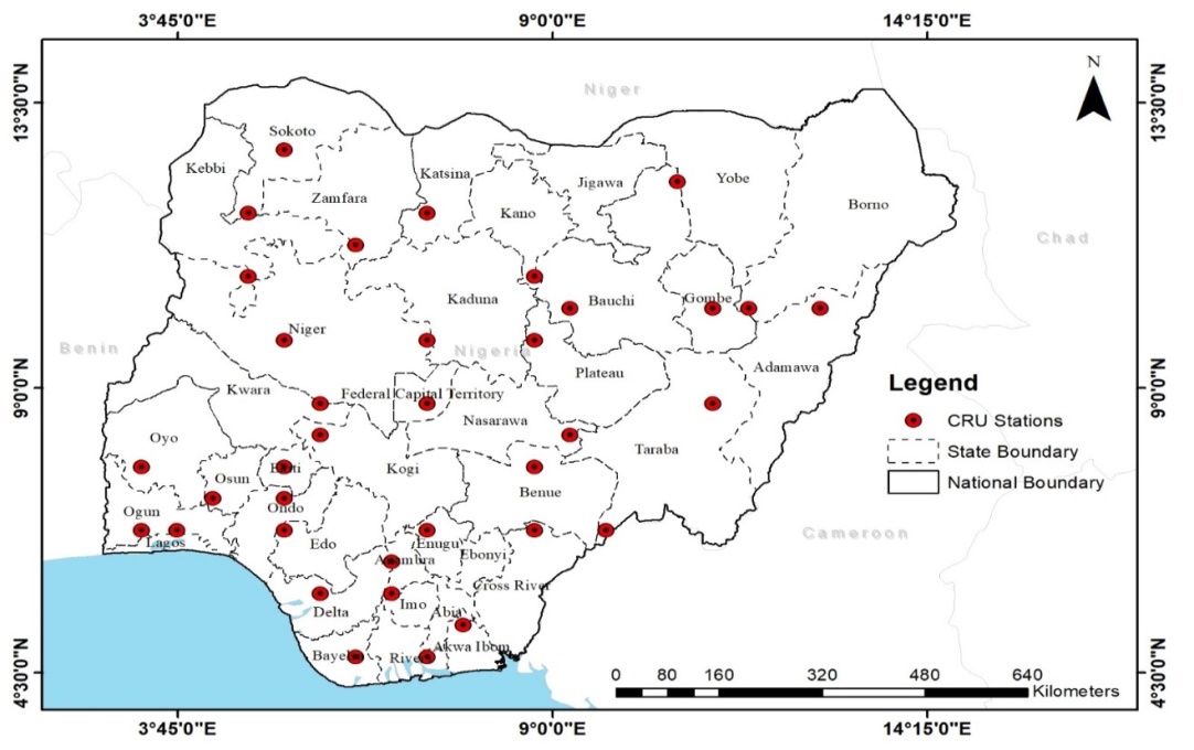
Figure 1: Nigeria Map Showing Climate Research Unit (CRU) Stations
Methodology
The study area comprises thirty-seven stations across Nigeria, and utilized monthly rainfall time series data from 1901 to 2021, collected from the archives of the Climate Research Unit (CRU) of the University of East Angelia. Data collection was based on rainfall distribution and amount within the study area. The data collected were statistically analysed with both descriptive and inferential statistical techniques. The descriptive statistical techniques were employed to summarize the characteristics of rainfall in the study area; while the analysis of variance (ANOVA) was used to ascertain the difference between the mean values of rainfall amongst the different eco-climatic regions.
Results and Discussion
3.1. Variability of Rainfall
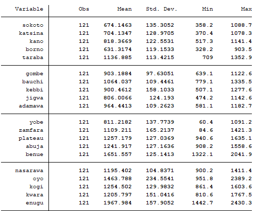
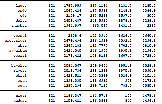
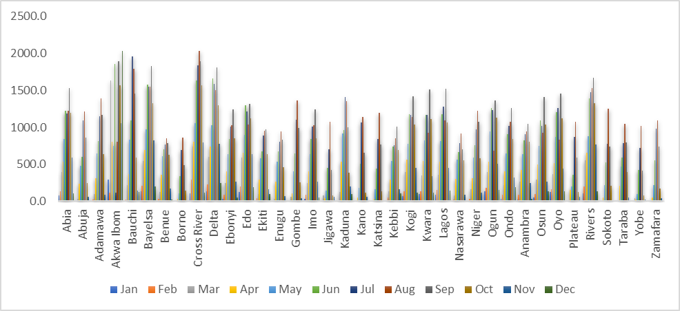
The results of statistical analysis performed on the rainfall data-sets over the thirty-seven stations are shown below. The annual rainfall amount from 1901 to 2021 showed that Nigeria had annual rainfall of 1488.6mm. Figure 2 showed that the wettest year is 1957 with an annual mean rainfall of 1792.7mm; followed by 1954 (1756.5mm), and 1901 (1730.2mm) and the lowest rainfall year is 1983 (1108.3mm). The mean, Standard deviation, minimum and maximum are presented in Tables 1 and 2. The spatial distribution of rainfall in Nigeria indicates that Cross River had the highest mean rainfall of 2679.5mm, Akwa Ibom had 2624.1mm, with the lowest recorded in Borno (631.3mm). On Std. Dev. the highest rainfall of 317.1mm was observed in Lagos, and the lowest rainfall of 97.6mm was recorded in Gombe. The highest minimum rainfall of 2092.2mm was recorded in Cross River while the lowest of 60.4mm and 84.6mm was recorded in Yobe and Zamfara. The highest maximum rainfall of 3286.1mm was recorded in Cross River; others include Akwa Ibom (3196.1mm), Bayelsa (3028.3mm), and Rivers (3090.9mm). The lowest maximum rainfall was recorded in Borno (903.5mm). On the monthly distribution of rainfall in Nigeria, Table 2 indicates that August had the highest mean of 1134.5mm; others include September (1131.1mm) and July (1058.6mm). The amount of rainfall presented in terms of monthly mean increases from the lowest value of 47.3mm in January to the highest value of 134.5mm and 1131mm in August and September thereafter reducing again. The highest Std. Dev. of 451.4mm was recorded in October, followed by September (421.8mm) with the lowest rainfall of 64.3mm in January. The highest minimum rainfall of 687.2mm was recorded in August; followed by February (1mm). The highest maximum rainfall of 2036.5mm was in August; followed by December (2029.7mm). While the lowest of 290mm was recorded in January and February respectively. The standard deviation, minimum, and maximum all fluctuate together with the mean to show the degree of dispersion from that mean. As indicated in Figure 3 Edo, Delta, Bayelsa, Rivers, Akwa Ibom and Cross River respectively south-south states with the highest monthly rainfall were recorded in Akwa Ibom with 1852.3mm (June), 114.6mm (July), 804.5mm (August) and 1893.3mm (September). Anambra, Enugu, Imo, Ebonyi, and Abia south-east states in Nigeria with the highest rainfall being recorded in Abia with 1228.3mm (June), 1186.2mm (July), 1221.6mm (August), and 1528.4mm (September). Oyo, Ogun, Osun, Ondo, Ekiti and Lagos southwest states with the highest rainfall been recorded in Lagos with 1175.1mm (June), 1281.4mm (July), 1094.2mm (August), 1518.3mm (September). Yobe, Borno, Gombe, Bauchi, Adamawa, and Taraba are northeast states with the highest rainfall in Bauchi with 1096.9mm (June), 1956.2mm (July), and 1789.2mm (August), and 1453.1mm (September). Jigawa, Kano, Katsina, Zamfara, Sokoto, and Kebbi northwest states in Nigeria with the highest rainfall in Kaduna with 1413.1mm (June), 1350.0mm (July), 1000.9mm (August), and 387.9mm (September). While, Plateau, Benue, Nasarawa, Abuja, Kogi, Kwara and Niger in north-central Nigeria with the highest rainfall in Kwara with 972.2mm (June), 1220.7mm (July), 1079.3mm (August), and 580.0mm (September).
The south-south regions have a long rainy season that begins in March and lasts until the end of July, with a peak period in June or July. It is a period of thick clouds and is excessively wet all year, especially in the Niger Delta region and the coastal lowlands. Figure 1 showed that this region had a peak in June or July, with a short dry season experienced in August, which is known as August Hiatus or Spell. After that, there is a wet period that lasts from early September until mid-October, with a peak around the end of September. The two periods of rainfall intensity give the double maxima phenomenon of the rainy season characteristic of southern Nigeria. The central regions are governed by a well-defined single rainy season (April - September) and a dry season (December to March). Also worthy of note is that across all the states in Nigeria, there are changes in the rainfall pattern. Although in recent years, there has been a disruption in the occurrence of this break and Odjugo, (2010) [24] identifies it as evidence of climatic change. Nonetheless, anthropogenic activities, which include deforestation, oil exploration and exploitation, over-cultivation etc., have altered the climate of Nigeria. Rainfall is experienced throughout the year in Nigeria, with the most significant rainfall occurring from April – October and with minimal rainfall occurring from November to March. Research has shown that rainfall in Nigeria is mediated by three distinct conditions including convectional, frontal and orographical determinants.
Figure 2: Annual Rainfall in Nigeria from 1901 to 2021
Table 1: Summary of Spatial Distribution of Rainfall in Nigeria
Table 2: Summary of Monthly Distribution of Rainfall in Nigeria
Figure 3: Monthly Rainfall Distribution in Nigeria
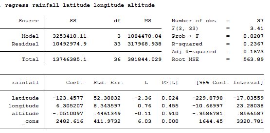
3.2: Factors Affecting Rainfall in Nigeria
The determining factors affecting rainfall amount and distribution in Nigeria are summarized and presented in table 3.
Table 3: Summary of Factors Affecting Rainfall in Nigeria
As indicated in Table 3, the linear regression results established that latitude statistically predicted rainfall in Nigeria, F (3, 33) = 3.41, P = 0.05 and latitude, longitude, and altitude accounted for 16.7% of the explained variability in factors affecting rainfall in Nigeria. The regression equation was: predicted rainfall = 2482.6 + -123.5 + 6.305 + -.0510x (latitude, longitude and altitude).
Table 4: Summary Results for ANOVA
Source of Variation
SS
df
MS
F
P-Value
F crit
Between Groups
1663312628
36
46203129
1546.194
0.000
1.419334
Within Groups
132675356
4440
29881.84
Total
1795987984
4476
*P < 0.05, it is therefore significant
Table 4 indicates the ANOVA results output generated from QI macros which showed that there was a statistically significant difference between the mean in all states in Nigeria as determined by one-way ANOVA (F (36, 4440) = 1.419334, P = 0.000). A Dunnett post hoc test showed that mean rainfall was statistically significant in Cross River, Akwa Ibom, Bayelsa, Rivers, Delta, Abia, Owerri, Ebonyi, Edo, Enugu, Anambra, Lagos, Benue, Ondo, Oyo, Ekiti, Osun, Ogun, Plateau, Kogi, Abuja, Kwara, Nasarawa, Niger, Kaduna, Taraba, Zamfara, Bauchi, Adamawa, Gombe, Kebbi, Kano, and Yobe, Jigawa. There was no statistically significant difference between the mean rainfall in Sokoto, Katsina and Borno.
Table 5: Summary of Levne’s Results
Levene's
Test
14.549
p
0.000
a
0.05
P < 0.05, it is therefore significant
The results of the Levene test showed that the alternative hypothesis is maintained and there is a difference between the variance of the thirty-seven stations in Nigeria. Thus, the thirty-seven stations come from populations with different variances.
Conclusion
The outcome of the study indicates that Nigeria had a general mean rainfall of 1488.6mm that ranged from 1108.3mm to 1792.7mm and a monthly rainfall of 223.3mm – 1076mm and the wettest year of being recorded in 1957 (1792.7mm). On spatial variations of rainfall in Nigeria Cross River had the highest mean rainfall of 1852.3mm in June in the south-south region. Lagos had the highest rainfall of 1175mm in June in the southwest. Kaduna had the highest rainfall of 1413,1mm in June in the northwest. Kwara had the highest rainfall of 972.2mm in June in the north-central. Bauchi had the highest rainfall of 1096.9mm in June in the northeast, and Abia in the southeast had the highest rainfall of 1228.3mm in June. On factors affecting rainfall in Nigeria, the linear regression results established that latitude statistically predicted rainfall in Nigeria.
Conflict of Interest:
The authors declare that they have no conflict of interest.
Funding: No funding sources
Ethical approval: The study was approved by the Institutional Ethics Committee of Universitas Negeri Makassar
References
Scalzitti, Jason, Courtenay Strong, and Adam Kochanski. "Climate change impact on the roles of temperature and precipitation in western US snowpack variability." Geophysical Research Letters 43.10 (2016): 5361-5369. Available at: https://doi.org/10.1002/2016gl068798.
Xu, Yu, et al. "Spatial and temporal trends of reference crop evapotranspiration and its influential variables in Yangtze River Delta, eastern China." Theoretical and Applied Climatology 130 (2017): 945-958. https://link.springer.com/article/10.1007/s00704-016-1928-1
Akande, Adeoluwa, et al. "Geospatial analysis of extreme weather events in Nigeria (1985–2015) using self-organizing maps." Advances in Meteorology 2017 (2017). https://doi.org/10.1155/2017/8576150
Falaiye, O. A., A. G. Olaitan, and S. C. Nwabachili. "Parametric analysis of rainfall variability over some selected locations in Nigeria." International Journal of Climate Research 5.1 (2021): 35-48. DOI: 10.18488/journal.112.2021.51.35.48
Ndakara, O. E., and O. A. Eyefia. "Spatial and seasonal variations in rainfall and temperature across Nigeria." Journal of Biodiversity and Environmental Sciences 18.6 (2021): 79-92. https://innspub.net/jbes/spatial-and-seasonal-variations-in-rainfall-and-temperature-across-nigeria/
Ndakara, O. E. "Hydrological nutrient flux in isolated exotic stands of mangifera indica linn: implications for sustainable rainforest ecosystem management in south-southern Nigeria." Nigerian Journal of Science and Environment 14.1 (2016): 125-131.
International Panel on Climate Change [IPCC] (2012). Managing the Risks of Extreme Events and Disasters to Advance Climate Change Adaptation.
Igwenagu, C. M. "Trend analysis of rainfall in Nigeria by some states from 2002 to 2012." Int J Sci Eng Res 5 (2014).
Onyekuru, Anthony N., and Rob Marchant. "Climate change impact and adaptation pathways for forest dependent livelihood systems in Nigeria." African Journal of Agricultural Research 9.24 (2014): 1819-1832. https://academicjournals.org/article/article1402999015_Onyekuru%20and%20Marchant.pdf
Ta, S., et al. "West Africa extreme rainfall events and large-scale ocean surface and atmospheric conditions in the tropical Atlantic." Advances in Meteorology 2016 (2016): 1-14. http://dx.doi.org/10.1155/2016/1940456”
Efe, S. I., and E. O. Ndakara. "Impact of Climate Variability on Crimes in Warri Delta State, Nigeria." Reading in Homeland Security and Development, A Publication of the Faculty of the Social Sciences, Delsu Abraka, Nigeria (2010): 17-24.
Ukoji, C., and O. E. Ndakara. "Abattoir waste discharge and water quality in Anwai River, Nigeria." Hmlyn J Agr 2.4 (2021): 8-14. DOI:10.47310/Hja.2021.v02i04.002
Ndakara, O. E., Atuma, I. M. (2021): Ecological Effects and Vulnerability Assessment of Flooding in Udu Local Government Area, Delta State, Nigeria; Nigerian Journal of Environmental Sciences and Technology (NIJEST), 6 (1): 160-171. https://doi.org/10.36263/nijest.2022.01.0330
Akinsanola, Akintomide Afolayan, and Kehinde Olufunso Ogunjobi. "Analysis of rainfall and temperature variability over Nigeria." Global Journal of Human-Social Science: B Geography, Geo-Sciences, Environmental Disaster Management 14.3 (2014): 1-17.
Adenodi, R. A. "A centurial analysis of rainfall variability in Nigeria." Nigerian Journal of Technology 37.2 (2018): 543-547. .http://dx.doi.org/10.4314/njt.v37i2.34
Thornton, P.K. (2014). Rainfall and Rainfall Variability. In: Sebastian K, (Ed). Atlas of African agriculture research and development: Revealing agriculture's place in Africa. Washington, D.C.: International Food Policy Research Institute (IFPRI), 7:38-39. Retrieved through https://cgspace.cgiar.org/handle/10568/53102.
Muktara, Abdullahi, et al. "Rainfall change detection in Africa using remote sensing and Gis between 1999–2018." Big Data In Water Resources Engineering (BDWRE) 1.2 (2020): 52-54. DOI: http://doi.org/10.26480/bdwre.02.2020.52.54
Efe, S.I. & Ndakara, O. E. (2012): Climate, Man and the Environment. In: Philosophy of the Social Sciences; Awaritefe and Mukoro (ed.). A publication of the Faculty of the Social Sciences, Delsu Abraka. Pp 73-82.
Owolabi, J.T. (2016): Trend Analysis of Rainfall and Temperature, in Ado-Ekiti, Ekiti State, Nigeria. IIARD International Journal of Geography and Environmental Management ISSN 2504-8821 2(2) 6, www.iiardpub .org.
Wali, E., Abdullahi M., Nwankwoala, H, O, Ekwezuo, C., Hemba, S., & Ocheje, J. F, (2020). Analysis of temperature and rainfall variability over two coastal states in the Niger Delta, Nigeria", Annals of Geographical Studies, 3(2), 1-6.
Okwuokei, Tobechukwu Louis, and Ofudjaye Emmanuel Ndakara. "Resource exploitation and tree species populations dynamics in the rainforest of Southern Nigeria." Quest Journal of Research in Environmental and Earth Sciences 8.11 (2022): 97-101.
Owho, O., and O. E. Ndakara. "Progress on Sustainable Development Goal for sanitation and hygiene in sub-Saharan Africa." Journal of Applied Sciences and Environmental Management 26.6 (2022): 1143-1150. http://www.ajol.info/index.php/jasem
Ndakara, O. E. "Biogeochemical consequences of hydrologic conditions in isolated stands of Terminalia cattapa in the Rainforest Zone of Southern Nigeria." Special Publication of the Nigerian Association of Hydrological Sciences (2012): 134-144. https://citeseerx.ist.psu.edu/document?repid=rep1&type=pdf&doi=76c93d55586099c140f9261a069e8dd53a26ffff
Odjugo, Peter AO. "Regional evidence of climate change in Nigeria." Journal of geography and regional planning 3.6 (2010): 142-150.
Advertisement
Recommended Articles
Research Article
Study of Marination of Broiler Chicken with Garlic on Water Holding City, Cooking Loss, Tenderness and Number of Bacteria
Lilis Suryaningsih,
...
Dicki Tri Utama
Published: 20/06/2025
Download PDF
Cite
x
APA
Suryaningsih, L., Gumilar, J., Setyadi Putranto, W., Wulandari, E., None, P. & Tri Utama, D. (2025). Study of Marination of Broiler Chicken with Garlic on Water Holding City, Cooking Loss, Tenderness and Number of Bacteria. Himalayan Journal of Agriculture, 6(1), 1-4.
MLA
Suryaningsih, Lilis, et al. "Study of Marination of Broiler Chicken with Garlic on Water Holding City, Cooking Loss, Tenderness and Number of Bacteria." Himalayan Journal of Agriculture 6.1 (2025): 1-4.
Chicago
Suryaningsih, Lilis, Jajang Gumilar, Wendry Setyadi Putranto, Eka Wulandari, Pratama and Dicki Tri Utama. "Study of Marination of Broiler Chicken with Garlic on Water Holding City, Cooking Loss, Tenderness and Number of Bacteria." Himalayan Journal of Agriculture 6, no. 1 (2025): 1-4.
Harvard
Suryaningsih, L., Gumilar, J., Setyadi Putranto, W., Wulandari, E., None, P. and Tri Utama, D. (2025) 'Study of Marination of Broiler Chicken with Garlic on Water Holding City, Cooking Loss, Tenderness and Number of Bacteria' Himalayan Journal of Agriculture 6(1), pp. 1-4.
Vancouver
Suryaningsih L, Gumilar J, Setyadi Putranto W, Wulandari E, Pratama P, Tri Utama D. Study of Marination of Broiler Chicken with Garlic on Water Holding City, Cooking Loss, Tenderness and Number of Bacteria. Himalayan Journal of Agriculture. 2025 Jan;6(1):1-4.
Download PDF
Research Article
Mating behaviour of Cavariella aegopodii
Nidhi Dhatwalia
Published: 19/07/2024
Download PDF
Cite
x
APA
Dhatwalia, N. (2024). Mating behaviour of Cavariella aegopodii. Himalayan Journal of Agriculture, 5(1), 1-7.
MLA
Dhatwalia, Nidhi. "Mating behaviour of Cavariella aegopodii." Himalayan Journal of Agriculture 5.1 (2024): 1-7.
Chicago
Dhatwalia, Nidhi. "Mating behaviour of Cavariella aegopodii." Himalayan Journal of Agriculture 5, no. 1 (2024): 1-7.
Harvard
Dhatwalia, N. (2024) 'Mating behaviour of Cavariella aegopodii' Himalayan Journal of Agriculture 5(1), pp. 1-7.
Vancouver
Dhatwalia N. Mating behaviour of Cavariella aegopodii. Himalayan Journal of Agriculture. 2024 Jan;5(1):1-7.
Download PDF
Research Article
The Effect of Marination Duration using Tamarind Paste (Tamarindus indica L.) on pH, Tenderness, Water-holding Capacity and Cooking Loss of Spent Layer Meat
Dina Ayu Wulandari,
...
Dicky Tri Utama
Published: 30/06/2024
Download PDF
Cite
x
APA
Wulandari, D. A., Suryaningsih, L. & Utama, D. T. (2024). The Effect of Marination Duration using Tamarind Paste (Tamarindus indica L.) on pH, Tenderness, Water-holding Capacity and Cooking Loss of Spent Layer Meat. Himalayan Journal of Agriculture, 5(1), 1-12.
MLA
Wulandari, Dina A., Lilis Suryaningsih and Dicky T. Utama. "The Effect of Marination Duration using Tamarind Paste (Tamarindus indica L.) on pH, Tenderness, Water-holding Capacity and Cooking Loss of Spent Layer Meat." Himalayan Journal of Agriculture 5.1 (2024): 1-12.
Chicago
Wulandari, Dina A., Lilis Suryaningsih and Dicky T. Utama. "The Effect of Marination Duration using Tamarind Paste (Tamarindus indica L.) on pH, Tenderness, Water-holding Capacity and Cooking Loss of Spent Layer Meat." Himalayan Journal of Agriculture 5, no. 1 (2024): 1-12.
Harvard
Wulandari, D. A., Suryaningsih, L. and Utama, D. T. (2024) 'The Effect of Marination Duration using Tamarind Paste (Tamarindus indica L.) on pH, Tenderness, Water-holding Capacity and Cooking Loss of Spent Layer Meat' Himalayan Journal of Agriculture 5(1), pp. 1-12.
Vancouver
Wulandari DA, Suryaningsih L, Utama DT. The Effect of Marination Duration using Tamarind Paste (Tamarindus indica L.) on pH, Tenderness, Water-holding Capacity and Cooking Loss of Spent Layer Meat. Himalayan Journal of Agriculture. 2024 Jan;5(1):1-12.
Download PDF
Research Article
The Role of Indigenous Microbes and Earthworm in the Bioconversion of Dairy Wastewater Solids into Organic Fertilizer
Marlina ,
...
N. Meynadhea
Published: 17/01/2024
Download PDF
Cite
x
APA
None, M., Rahayu, N. A., Badruzzaman, D. Z., Hidayati, Y., Harlia, E., Kurniawan, E. & Meynadhea, N. (2024). The Role of Indigenous Microbes and Earthworm in the Bioconversion of Dairy Wastewater Solids into Organic Fertilizer. Himalayan Journal of Agriculture, 5(1), 1-7.
MLA
None, Marlina, et al. "The Role of Indigenous Microbes and Earthworm in the Bioconversion of Dairy Wastewater Solids into Organic Fertilizer." Himalayan Journal of Agriculture 5.1 (2024): 1-7.
Chicago
None, Marlina, N. A. Rahayu, D. Z. Badruzzaman, Y.A. Hidayati, E. Harlia, E. Kurniawan and N. Meynadhea. "The Role of Indigenous Microbes and Earthworm in the Bioconversion of Dairy Wastewater Solids into Organic Fertilizer." Himalayan Journal of Agriculture 5, no. 1 (2024): 1-7.
Harvard
None, M., Rahayu, N. A., Badruzzaman, D. Z., Hidayati, Y., Harlia, E., Kurniawan, E. and Meynadhea, N. (2024) 'The Role of Indigenous Microbes and Earthworm in the Bioconversion of Dairy Wastewater Solids into Organic Fertilizer' Himalayan Journal of Agriculture 5(1), pp. 1-7.
Vancouver
Marlina M, Rahayu NA, Badruzzaman DZ, Hidayati Y, Harlia E, Kurniawan E, Meynadhea N. The Role of Indigenous Microbes and Earthworm in the Bioconversion of Dairy Wastewater Solids into Organic Fertilizer. Himalayan Journal of Agriculture. 2024 Jan;5(1):1-7.
Morrison, A. I., Emmanuel, N. O. & Ighovie, E. S. (2023). Analysis of Rainfall Distributions and Variations in Nigeria. Himalayan Journal of Agriculture, 4(2), 1-8.
MLA
Morrison, Atuma I., Ndakara O. Emmanuel and Efe, S. Ighovie. "Analysis of Rainfall Distributions and Variations in Nigeria." Himalayan Journal of Agriculture 4.2 (2023): 1-8.
Chicago
Morrison, Atuma I., Ndakara O. Emmanuel and Efe, S. Ighovie. "Analysis of Rainfall Distributions and Variations in Nigeria." Himalayan Journal of Agriculture 4, no. 2 (2023): 1-8.
Harvard
Morrison, A. I., Emmanuel, N. O. and Ighovie, E. S. (2023) 'Analysis of Rainfall Distributions and Variations in Nigeria' Himalayan Journal of Agriculture 4(2), pp. 1-8.
Vancouver
Morrison AI, Emmanuel NO, Ighovie ES. Analysis of Rainfall Distributions and Variations in Nigeria. Himalayan Journal of Agriculture. 2023 Jul;4(2):1-8.